 The next stage of the walk was the week before the August Bank Holiday, this time in the company of Jan Davenport - a work friend, walking friend, whatever description you want, although friend probably says it best. Jan was off work on her main fortnight’s holiday but wasn’t going away; I had booked just the one day off to join her for a day’s walking so we would have to take whatever the weather chose to give us and initially it appeared that it would be a cold, damp day. As we made our way along the A55 it had looked grey and overcast but we reminded ourselves that the forecast was for better later in the day - in any event, it was a damn sight better than being at work, as we both agreed. Jan was already well aware of my musical taste and after putting up with a compilation of coastal-themed music she pulled a few of her own CDs from her bag “just to brighten things up a little”. So it was that the car resounded to the slightly more cheerful tunes of Michael Jackson as we crossed the bridge to the island.
We’d given ourselves plenty of time - the plan was to catch the bus from Pentraeth to Beaumaris and then walk back, which had the advantage of not tying us down to a timetable to complete the walk by, and maintaining the anti-clockwise direction of the guide book - and I had promised a bacon butty as the prelude to the expedition, so after a brief pause to take in the view of the suspension bridge from a lay-by on the A5 we pulled up in the village of Menai Bridge itself. It wasn’t too difficult to find a café providing the said snack and delicious they were too (it is only right that I confess to also having partaken) and we were soon on our way once more, with the chance of a small detour to let Jan see the village of Benllech, which was beyond our target for the day.
We still had plenty of time to park up in the small car park in Pentraeth, pull on walking boots and rucksacks and confirm that we were standing at the appropriate bus stop for the Llangefni -Bangor bus. It was fortunate that we had confirmed it, for when it arrived the bus showed little or no sign of stopping until I stepped forward and it came to a shuddering last minute halt - had it not done so, it would have been a further four hours until the next so would have meant a fairly expensive taxi ride, or a major change in plans. We were quickly to discover that the devil may care attitude of the driver to bus-stops also applied to his driving. The lanes down which we drove were pretty narrow but he seemed to have no fear of meeting anything coming in the opposite direction and hurtled along as though his life depended upon it (as opposed to our lives). Anyway, we somehow avoided collision with anyone and were dropped off outside the Castle Bakery - the main branch of the very café we had earlier dined at in Menai Bridge. We resisted further temptation, made use of the town’s toilet facilities and set our feet towards the shore, giving the castle but a fleeting glance on this occasion as we were keen to be underway.

We headed for the lifeboat station which is situated beyond a grassy car park, immediately alongside the town’s jetty and soon spied the coastal path signpost with its circular symbol incorporating a picture of a common tern - the signs are well-made and in most cases (although not all, as we shall see) are easy to spot when looking for navigational help. The sign indicated we should turn left along the sea wall but before we did we paused to take in the quite magnificent views across to the mainland. The tide was in - indeed, it was occasionally throwing a wave up and over the wall and wetting the width of the path ahead - and the absence of any mudflats certainly enhanced the picture in front of us. A friendly granddad, out with his pre-school granddaughter, was good enough to suggest that we amble forty or fifty yards and inspect the panoramic drawing with all points of interest duly labelled for our delectation. Jan was disappointed that you couldn’t see Snowdon - we had climbed it two years earlier in the company of Dave, my best man, and she was keen to get a perspective of just how high it actually was - but was happy to be able to identify the Great Orme away to the east. From this distance the Orme looked like an island as the low lying land that connected it to the mainland was hidden, whilst the wind turbines in the sea beyond were clearly visible . What we couldn’t quite see was Puffin Island - we would be taking lunch at Penmon Point immediately opposite and Jan would doubtless have liked an indication of the distance we needed to cover before we were able to rest.
I had indicated that the walk would be some twelve miles or so, but had failed to mention that the car park was a further mile inland. Nonetheless, it was a walk that was quite within Jan’s capabilities and we were anticipating a finish of about four-thirty to five o’clock - a sad misjudgement as it turned out but not something to spoil a quite glorious day “stolen” from the daily grind (we had chosen a Thursday, which had the benefit of meaning less traffic but the absolute disadvantage of meaning I would need to be back at my desk the following morning. This, however, gave a slightly illicit feeling to the day and the knowledge that our friends and colleagues remained chained to their desks made us all the more appreciative of the brief respite the day gave us.)
Having taken in the view we set off in determined fashion, avoiding the waves breaking still further across the path in twinkle-toed manner and gently climbed a grassy slope to a point where the views became still more spectacular and the first of many stops for photographs was taken. Jan pulled on her waterproof as a protection against the wind - the first of many adjustments to her layering system to regulate temperature during the day - and we breathed deep in the sense of freedom from worldly cares. All worries dissipated, we only cared about the pleasures that the next few hours would bring - as long as we kept the sea to our right, we should be OK. All that mattered was finding our way back to the car - and the promise of fish and chips at Jan’s favourite chippy in Llandudno to end the day on a high note.
We dropped down the far side of the slope and were a little disappointed to find that our path was initially the pavement of the busiest road on the south-east of the island - not a motorway by any means but with a fairly steady stream of traffic it seemed to us. The sea was immediately to our right and were the tide low we could have made use of the beach but on this occasion it wasn’t to be and whilst we were happy to wander along chatting of this and that, it was in single file rather than two abreast in order to keep us both off the road itself.
What we’d hoped would only be a few yards of road walking became closer to a half mile when we realised that the state of the tide meant that a stroll along the beach was out of the question and we would be forced to continue along the road for a pretty hairy couple of hundred yards on a blind bend with no footpath. I actually did the decent thing and went first rather than have Jan shield me from the oncoming traffic. It wasn’t long before we regained the footpath, though, and we had the opportunity to take a leisurely look at some very nice properties - those on the right of the road almost certainly having wonderful views over Fryars Bay to the rear. Welsh architecture in general can tend a little to the dark and gloomy - especially with all the slate - but many houses here on the coast are rendered in pristine white, which gives them a clean and modern look. They no doubt need regular repainting but do enhance the view.
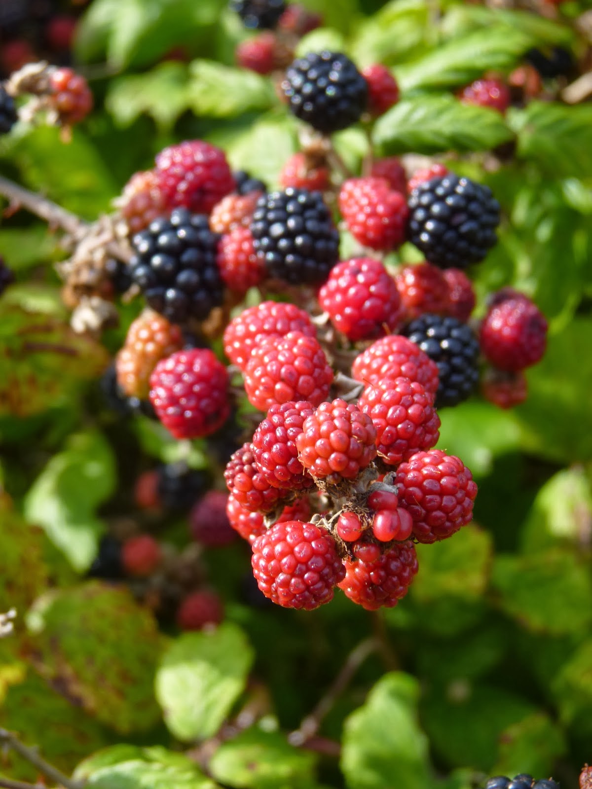 Despite the kerb appeal of the houses, we had come for a coastal walk and were keen to get back to the sea as soon as possible, at the very least to feel that we were out in the countryside, so it was a good sign to turn right onto a single track road bordered by hedges laden with berries - blackberries, blueberries, and raspberries all ripening nicely in the late summer sun. It was still road-walking for the time being but much more pleasant than what had gone before - there was scarcely any traffic so we were able to relax and spread out cross the road. After half an hour or so the tiny River Lleiniog appeared to our left and a patch of marshy ground covered in Himalayan balsam . Had we turned left we would have taken a little footpath and had the chance to visit Lleiniog Castle, or at least the ruins thereof, but our hearts were set on the coast and we could smell the saltwater just a couple of hundred yards away.
A little wall where the tiny river met the sea was an ideal venue for the first stop of the day and a lovely cup of coffee from the flask. Happily both Jan and I like our coffee quite strong, so could share hers and leave mine to keep as hot as possible for later. It had been pleasant walking so far - that half mile of main road excepted - but I think we were both keen to get closer to the coast and to feel the earth beneath our feet and scoured the guidebook and map to see how soon we would get our wish. The answer was “not for a little while yet” but nonetheless things were about to take a turn for the better. The road remained extremely quiet, giving views across open fields to the Menai Straits and the mainland beyond and soon took a sharp turn downhill to meet the coast head on. Beyond a couple of cottages - unusually, they looked as though they were in need of a little TLC - another sharp turn, this time to the left, meant we were now walking parallel to the strait itself. A bench immediately alongside the road carried the warning sign “This bench should be used at your own risk”, which tended to make you a little nervy about using it - anyway, we had only had a sit down a few minutes earlier so didn’t feel the need to make use if it. Almost opposite there was a little lay by and we made our way over to the far side to avoid the vehicles parked there - at the very moment that the wind and waves combined to throw a substantial volume of water up and over the sea wall and directly into our path. What made things worse was the sound of laughter from the camper van we had been forced wide to avoid - although in fairness, I’m sure we would have found it equally funny had the positions been reversed.
Slightly damper than before we marched on - still on tarmac but with the knowledge that we had left the worst of it behind us and the day could only get better. The weather had certainly improved, still breezy but with a blue sky now in evidence and although it was not yet hot it was unquestionably warmer than when we had started. To our left a shallow pond was home to a number of ducks and other wildfowl, the field surrounding to lapwing and curlew, while herring gulls and the more delicate black-headed gulls rode the breeze overhead. It was by now apparent that I had made the right decision in taking the day off work and I had a spring in my step as we strode onwards. As we walked we pondered on the especially high wall that bordered on the pond and came to the conclusion that it must have enclosed a deer park at some time - probably a part of the land belonging to the priory that was our next target. We were delighted to be proved correct in this supposition some minutes later when reading an information board at the building itself.

Penmon Priory stands at the point where the public highway becomes a toll-road leading down to the lighthouse at Penmon Point - of which more anon. Penmon consists of the parish church, partial ruins of the priory and well, a fishpond and a particularly ornate dovecote. It’s a charming little scene, marred somewhat by the fact that the car park takes a prominent location slap in the middle of the buildings, but charming nonetheless. The monastery was founded in the 6th century AD and dedicated to the early fifth century saint, Seiriol, of whom little is known these days. Reputedly a great friend of St Cybi, who lived in the north-west of the island and for whom Holyhead is named (Caergybi in its native tongue), he would apparently walk out across the island to meet him halfway before returning to Penmon in the evening - a pretty decent expedition these days, never mind in the years before tarmac, OS maps and a mobile phone to ring ahead and tell someone you’re behind schedule. As he would walk with the sun behind him, he became known as Seiriol the Fair, in contrast with his tanned friend, Cybi the Dark. The church remains dedicated to his memory, as is the well bubbling up crystal clear in a little shelter to the rear of the building.
 The priory was - as so many - ransacked and destroyed by Vikings in 971 AD, leaving behind just a couple of Celtic crosses and the decorative font. The crosses are now displayed inside the church, although this is a fairly recent development as one of them formed part of the deer park until as late as 1977. Two local kings rebuilt the monastery for use by Augustinian monks in the thirteenth century, the property consisting of a dining room on the first floor with cellar below and dormitory above - Gruffydd ap Cynan and Owain Gwynedd, two good Welsh names - and the fifteenth century saw further expansion with a kitchen and warming house. Of these only the earlier building remains - and imagination is needed, along with the information boards, to visualise the upper floors. Of course, like so many religious buildings, Penmon fell victim to the machinations of Henry VIII and his fall-out with the papacy and suffered dissolution in 1538.
Upon dissolution the land and buildings were transferred to the locally prominent Bulkeley family, who were then responsible for the building of the huge deer park wall that we had noted earlier. They also had the wonderful dovecote built, a large building, shaped almost like a bottle-kiln from inside with a hole in the roof through which the up to one thousand birds would gain access. Of course, not only did the birds provide eggs for the table, they were also used for meat and would have been a sign of the family’s importance. Another indication of their influence is the Bulkeley Hotel, the most prominent of buildings in Beaumaris overlooking the pier and lifeboat station. This wasn’t merely named for the family, but designed for them - by a Mr Hansom, architect of the parish, for whom the Hansom Cab was named, an indication of the regard he was held in nationally during the period.
That sunny August day Jan and I felt rather smug at the fact that we had arrived on foot and were not therefore subject to a car parking charge, or indeed the toll for using the road to its terminus at the coastguard station a half mile further on. We were able to wander at will amongst the buildings - in the care these days of Cadw, the Welsh equivalent of English Heritage - and whilst time prevented us from exploring inside the church , we were glad to pass the fishpond (more food for hungry monks) and its resident mallards to stroll up to the tiny building enclosing St Seirol’s Well. There isn’t much to see - it’s just a little stone hut that in a different location could be mistaken for a bus shelter - but even for someone like me who has little in the way of religious belief, it is clearly a special place and I could absolutely understand people making a pilgrimage to such a calm and peaceful spot. It is in these simple, unshowy buildings that I find it easier to appreciate religion than in so many of the wonderful cathedrals we have in this country, where I find myself admiring the architecture rather than pondering on the purpose.
 Time and tide wait for no man though and whilst Penmon was fascinating, the sun was by now beyond its zenith and we felt it necessary to drag ourselves away down the toll road to our promised lunch spot of Penmon Point itself. It’s only a ten or fifteen minute stroll away and views initially are limited but when they are revealed, are undoubtedly the highlight of the day. Puffin Island is the first to catch the eye, with the black and white striped lighthouse closer to us, with its stark warning not to pass between the lighthouse and shore - the deep channel is between Puffin Island and lighthouse, rather than the far side of the island but there are hidden rocks close to the main island that have been responsible for many a sunken ship and in particular the famous Rothesay Castle wreck.
The Rothesay Castle was a paddle steamer sailing out of Liverpool. On 17 August 1831 it left the Mersey with 150 passengers, heading into stormy weather under the control of an allegedly drunken captain and his minimal crew. As if this were not bad enough, the ship’s lifeboat had a badly damaged hull and a complete absence of oars. In the early hours of the 18th August it struck the rocks off Penmon and quickly foundered. Only twenty three souls survived of the one hundred and fifty. The inquest was held in Beaumaris and recorded that “had the Rothesay Castle been a seaworthy vessel and properly manned this awful calamity may have been avoided”. It was this incident that led to the establishment of a lifeboat station at Penmon. Between 1832 and its closure in 1915 the boat launched 46 times, which doesn’t seem a lot for 83 years - until you realise that it was responsible for saving 116 lives which strikes me as a pretty good ratio of two and a half lives saved for every time it was launched in anger. Since 1915 - when attention may well have been focused more on the trenches of Belgium and France than the sea-lanes of Wales - the Beaumaris lifeboat has assumed responsibility for the area and has continued the excellent work, whilst the lifeboat station has reverted to private use.
We have learnt a little of the history of Puffin Island earlier and have enjoyed some of its wildlife on the boat trip from Beaumaris so I shall not dwell on it further but it provides a glorious view and a fine backdrop to a picnic lunch.
 We could have enjoyed a cuppa and a bite to eat at the café housed in the old coastguard station but had opted for sandwiches and flasks instead - the bacon butty in the morning and planned fish and chip supper for the evening were probably more than enough carbs for the day anyway. The beach at this point largely comprises sea-smoothed pebbles and in the past people removed them on a near-industrial scale to sell-on in garden centres and the like. Happily, these are more enlightened times (at least as far as this is concerned - I make no greater claim than that we have a greater awareness of our impact upon the environment these days) and the problem seems to have eased somewhat. It makes it difficult to find somewhere comfortable to sit but we managed it by getting close in to the cliff and foregoing some of the sea view. We could see enough though for me to get quite excited about the prospect of a photo of the lighthouse with a yacht under full sail pass elegantly alongside and I was forced to scramble up the slight slope to the top of the shingle, whilst removing the lens cap and finding the appropriate setting for the shot. A professional would no doubt be disappointed with the result but I was entirely satisfied, as I was with the shot of a very small area of pebbles at my feet, just to illustrate how attractive what is, in essence, a pile of stones can be.
It was with regret that we re-packed our rucksacks and headed back to the route - not that we didn’t want to continue, but merely that we were enjoying the chance to relax and take the weight off our feet. I was, it is true, a little surprised at how long it had taken us to reach the Point and was conscious that we still had two-thirds of the day’s journey ahead of us but I was careful to keep this little snippet of information to myself for the time being and not affect Jan’s morale adversely. The way ahead lay along grassy bracken-edged tracks for a mile or so and we paused to drink in that wonderful view one last time, only for me to realise that I had dropped one of the camera’s attachments and have a sudden vision of retracing our steps for that mile or so back to our lunch-stop. Happily, Jan’s sharp eyes spotted the offending item to the side of the path before we had gone more than twenty yards and I was saved the ignominious return to the beach and a scramble amidst the stones surrounding our little lunchtime idyll.
 Once the bracken had been safely negotiated we had a number of farmer’s fields to pass through. Nothing very exciting but pleasant and with little to worry about in the navigation department. The only slightly disquieting thing was the signposts for a couple of other walks - one a circular walk to/from the priory and a “lighthouse walk” that sounded interesting but I’ve been unable to find out anything about subsequently. The path may have again deviated from the coast itself but the guide book does point out that “a number of tempting public footpaths do lead down to the coast but with no link between them you will be forced to retrace your steps”. The truth is that these public footpaths are many generations old and date to the time before people walked for pleasure; they were paths with a defined purpose and the likelihood is that they were paths between home and workplace - the sea and the fishing that provided a living. As such, there was little benefit in the paths diverting along the coast, for that is what the boats were for.
 After a number of these fields the path emerged onto a quiet and narrow lane, with high hedges filled with berries and honeysuckle. Occasional cottages lined the lane, mainly whitewashed and well-kept and often with extremely attractive and well-tended gardens. The occasional property let the side down but by and large they were adornments to the scene rather than detractions. We walked on, often in companionable silence, pointing out the odd item of interest and warning of the (very) occasional car - two constituted a rush hour - and enjoying the sun on our backs and the light, lilting breeze in our hair.
Somehow, somewhere along this stretch - and without either of us being aware of it at the time - the day was turning into something a little bit special. There are sometimes days like this, days that start slowly and just get better, days when the weather and scenery and company and serendipity come together so that you look back when it’s over and realise what a wonderful time you’ve had. Nothing spectacular needs to have happened - nothing did today - but they are the days that you lock away in the memory banks and treasure. This was becoming special, but so slowly, so subtly, that it was only in retrospect that either of us realised just how good it had been. If I had to put the time it happened down to one specific moment, though, I think it happened when we came upon three butterflies sunning themselves on the tarmac, so lost in their own little reverie that we were able to stand above them (avoiding casting our shadows upon them) and take a photo or two. They appeared either unaware of our presence, or unconcerned at the very least. I have read of butterflies sipping on the juices of over-ripe fruit and becoming intoxicated as a result. It appeared possible that this had happened here. They were small tortoiseshells, one of the more common of our British species but beautifully marked with black bars and smudges on a largely orange background, with the wings edged with delicate little pearl markings in a pale iridescent blue/white. I’m not sure that I’d ever examined a butterfly so closely before and found the creature charming in a way I had previously failed to appreciate. We all know that butterflies are lovely creatures and so take them for granted perhaps.
 Sadly we were forced to leave the three of them to idle away the afternoon by themselves for we still had much ground to cover. One of the things we had pointed out to each other was the occasional spot from where it was possible to see both north and south coasts of the headland at the same time and this merely showed just how little ground we had actually covered. We still felt little need to hurry - it was such a warm afternoon now that we had no desire to get more of a sweat on - but at the same time did not want to leave ourselves with too much to do late on. Little did we know then just how late a finish we would have.
A huge house now appeared in front of us - or at least the high garden wall did - and the footpath took a sharp left turn to skirt around it. There was a window high up in what seemed designed to give the appearance of a watch tower and we could only imagine how spectacular the views from there would have been - suffice it to say that any occupant would have been looking out to sea, rather than down at the footpath almost immediately below. Having taken a right hand turn around the corner of the wall the path opened out upon another lane - probably a continuation of the one we had left only moments before - and for the first time the way ahead lay seemingly unmarked. One of the circular “tern” signposts indicated a way opposite but after a couple of hundred yards and a pause to look at some pigs and the fattest sheep that I have ever seen in my life the path fizzled out with an electric fence blocking the way ahead. We looked around for an alternative but could see nothing and the guidebook was of little help. It is unfair to suggest that this was the fault of the guide, though, for we had not referred to it in so long that we were quite unsure of where we actually were or indeed which page we were on. It was an amateurish mistake and one for which I took full responsibility but it appeared that we must retrace our steps to the previous marker and regain our bearings. As we commenced the climb back uphill (it would be uphill) we spied a tiny, battered Ford Ka making its way down the drive of the huge house we had so recently circumnavigated. It pulled up alongside us as we regained the lane and the occupant rolled down the window. We were expecting to be told in no uncertain terms to “get off our land” so got in quickly with a polite enquiry about the way ahead. The man seemed a little taken aback and pointed to a semi-hidden track alongside the fence in the adjoining field. “The fingerpost’s a little offline here” he said. “People often miss it.” We didn’t point out that if that were the case he could (a) realign it to indicate the correct direction; or (b) ask the appropriate authority to do so, on the basis that he looked as though he could get violent, did have a couple of largish dogs in the back of the Ka, and we had absolutely no idea where we were but as he squeezed himself back into the driver’s seat for the long drive back to his house we did reflect that he must have been sitting and watching us make the original mistake and then jumped into the vehicle for the 400 yard journey to his front gate in order to accost us so promptly. Our thanks for his assistance were acknowledged, though, and were genuine. Without his indicating the path, we could still have been there now searching for the route. (This is, I should point out, the only occasion in the route to date where the signage has been found wanting.)

The track narrowed as it reached the end of the field before a stile gave entry to a wider track leading onto still another quiet lane. Now we knew where we were again, we made sure to keep an eye on the guide book and were told to make a right turn uphill and keep an eye open for a chapel. In our desire to keep to the route, we made an earlier turn than was strictly necessary and wasted another couple of hundred yards. A woman walking a dog put us right when asked - or at least indicated that she “didn’t think” there was a chapel further down that lane - and so we again retraced our steps and continued along the lane, where we were pleased to see that the route description matched the terrain on the ground. The chapel, when it came, was a little unprepossessing and situated so far from any habitation that it was a surprise to see that services were still held here. I liked the fact that it was stuck out here in the middle of nowhere but cannot conceive where its congregation comes from.
A couple of hundred yards beyond the chapel we made another turn, off to the right and the track to another remote farm. We had promised ourselves another short break when we reached this point - something to drive us on up the hill and through the heat - and so removed the sit mats from our rucksacks, the flasks from the side pockets and sat down to enjoy the mid-afternoon sun. Jan took the opportunity to phone home and make sure the kids were coping without her - they were - and then decided to rub in our absence from the office by texting Dave with the message that the sun was shining, the sky was blue and the wind in our hair; how was it in Stoke? His response came back quickly and contained more than a hint of jealousy. It came as some surprise that it was now approaching four o‘clock, but neither of us wanted to rush this and we each lay back for twenty minutes and basked in the warmth of the late afternoon sun. Sooner or later though we would have to push on and reluctantly we strapped the backpacks on one last time, confident that within the hour we would be removing our boots and setting the car towards Llandudno and the fish and chips that were already beckoning to us. How wrong our timing was.
The path soon left the farm track and headed off cross country once more, through fields full of quite possibly the whitest sheep I have ever seen - clearly they had been washed within the last couple of days, perhaps even the last couple of hours and were an excellent advertisement for the cleaning product the farmer had used. I did wonder, however, just how long their pristine appearance would last. Less pristine was the farm of Tan Dinas, some few hundred yards further. The path made its way between farmhouse and barns and it was hard to avoid the feeling that this was not a farm that had a great deal of love lavished upon it - although in fairness all of the animals that we saw looked fit and well-cared for and it may be that more care was lavished upon the animals than upon the farmer’s own welfare. Shortly beyond the farmyard a path leads off to the left and the hill fort of Din Silwy, situated high atop the hill known as Bwrdd Arthur (Arthur’s Table). Whilst the fort is apparently similar to the wonderfully well-preserved Din Lligwy, inland of Moelfre some six or seven miles further along the coast, and is undoubtedly more dramatic in its situation and as a viewpoint, it apparently requires a great deal more imagination to picture the settlement and we decided to walk on by on this occasion, having taken account of the time, the hints of weariness in our legs, and the distance still to go. It would prove to be a good decision.
Another cottage appeared in front of us and the signpost indicated a path along the inside of the garden fence before passing behind one of its outbuildings. This always feels a little uncomfortable - however much legal right is on your side, you’re still walking on someone else’s property and I am always careful to tread lightly and pass quickly so as to cause the minimum disturbance. It was therefore reassuring to see a sign on the outbuilding indicating a selection of photos could be viewed within and purchased should you so desire. Time not being on our side on this occasion, we declined to do so but applauded the sentiment. What I did take advantage of, though, was the tap alongside and the sign that indicated that walkers were welcome to refill their water bottles at will, or to make use of the bowl below to refresh their dogs. A lovely selfless gesture - so thank you Mrs Pearl Bucknall, for she was the photographer advertising her wares - and one that I trust is appreciated by all passers-by and not abused - whilst most walkers you meet are decent, upstanding members of society, it would be foolish to pretend that there are not those amongst us as selfish and anti-social as elsewhere in society. Jan declined the opportunity to replenish her water supply on the basis that we were on the last stretch now - a view that was reinforced within minutes as we began to descend sharply to the beach at the eastern end of Red Wharf Bay.

From above the beach was an enticing prospect. Sunlight glistened on its wide sandy acres as people enjoyed themselves in a variety of activities - walking, picnicking, flying kites - and I think we both envisaged a pleasant twenty minute amble along the beach before turning up the mile long track back to the car. Jan answered her mobile phone - Tom, her son, had a question about the whereabouts of his dinner - and advised that we would be back at the car and on the way home within forty-five minutes or so. She spoke of taking off her boots and wandering barefoot through the soft sand but decided against it when she realised she would have to put her boots back on again for that last mile and that with wet, sandy feet those boots could be made to feel extremely uncomfortable. Spirits were high, though, as we set off on a route parallel to the sea-wall that would have been our path at high tide. After ten minutes it was apparent that we seemed to have made little progress along the beach but the presence of a couple of blokes with a three-wheeled go-kart and a large kite - I think it’s called sandkarting - gave us some fine entertainment as they sought and failed to (a) properly launch the kite, and (b) enjoy the ride that being dragged along would give them. Such were their problems that we were easily able to keep pace with the two of them as they made their way downwind - indeed after a while we were having to crane our necks backwards to get a clear view, having overtaken and outstripped them until one particularly successful run took them three or four hundred yards before the kite plummeted to the sands once more and led to yet another rethink of technique. And so on we walked. And on. And on.
 I was pretty confident that I would recognise the cottage where we needed to turn and equally confident that we hadn’t passed it while enjoying the entertainment provided by the sandkarters but I was starting to get less confident by the minute as it seemed as though we had already been on the beach for far longer than I had anticipated. I checked the guidebook and map again and it was clear that I had underestimated the length of the beach - far from being a twenty minute amble, it was a two and a half mile trek before we headed off inland. Nonetheless, it seemed sensible that we make our way back to the shoreline in order to avoid missing our turn - our route had gradually taken us further away due to the dunes that form a barrier between beach and shoreline. It soon became apparent that this was easier said than done - we had left the dunes behind and it was now low-lying salt marsh that intervened, forcing us to ford a tiny stream or two and chart a zig-zag course from grassy tussock to grassy tussock, always aware that a loss of footing could mean the loss of a boot in thick, glutinous mud. Salt marshes are a fragile environment, always at risk of being washed away by heavier than normal tides, strong storms or a change in tidal patterns or sea currents. The plants that grow within the marsh are less delicate than their overall habitat, needing to be hardy to survive such a hostile environment. - samphire is the only one I can really identify from having seen TV presenters such as Ray Mears eat it to demonstrate their foraging credentials, as it is perfectly edible and a ready alternative to other green vegetables. I had mixed feelings, therefore, in trampling through the marsh in such large and heavy boots but it was now gone six o’clock, the sun was fading, Jan was obviously weary and I didn’t want to lose any more face by being too far from the shore to spot our path when it finally arrived. We safely reached the shoreline (clearly - I would not be writing this otherwise) and were able to pull ourselves up and onto the seawall path but it had been an exertion that neither of us really needed at this late stage in the day and my promises that we “couldn’t be far now” looked like falling on deaf ears.
Whilst she remained cheerful and there was no attempt at blaming me for the predicament, Jan was now undoubtedly shattered - and I was a little weary myself if I am to be honest. The occasional rabbit on the track kept spirits up - I hadn’t thought of them as coastal creatures before but they seemed completely at home - as did sightings of the occasional wader, beaks in the shallow water as they search for molluscs, shellfish and invertebrates according to taste. We saw curlew and oystercatchers certainly, and possibly dunlin as well and I was pleased to see a heron fly in to land some twenty or thirty yards away and commence its elegant stalking of small fish, frogs and toads. None of this was getting us any nearer home though, and I pointed out that if we were to speed up a little it would reduce the time we still had to walk. To her immense credit, Jan managed to raise the pace for a few minutes and was delighted when I was able to point out with absolute certainty that the cottage at Pen y Lon had finally come into view. We turned to look back for one last time at the seemingly never-ending bay and then without a further backward glance turned inland.
Of that final mile there is little to tell. I picked up a stone in my shoe and stopped to remove it, only for Jan to inform me that I would have to catch her up - “If I stopped now, I wouldn’t be able to start again” - but spirits were high and even the realisation that the last two hundred yards were uphill could not spoil the immense satisfaction of having completed a wonderful fourteen miles. All that remained now was to make our way to Llandudno and those famous fish and chips.
Regrettably, by the time we pulled up outside what is, remember, Jan’s favourite chip shop in all the world, frying was over for the day and the doors closed. We made our way instead into the town centre, somehow found a parking spot in its crowded streets and found a “fish restaurant” that was within budget. Reinforcing my opinion that she had enjoyed a wonderful day and there were no recriminations about its length, Jan insisted upon paying for the meal - in truth she had insisted that she would from first thing this morning, as a result of which I had bought the bacon butties back in Menai Bridge. Whilst more expensive than would have been the case at the other venue, the cod was pronounced excellent and the chips entirely satisfactory. We relived the day’s walk, agreed it had been a splendid expedition and that we would each sleep well when we finally got home. A quick visit to their toilet facilities and we would be away. Jan went upstairs first of all, without incident but when I returned from my own brief visit I was conscious that I seemed to be attracting attention from some of my fellow diners. Jan put me right on the reason for this when I got back to the table. “Your flies are undone,” she whispered. A less than perfect end to a near perfect day.
No comments:
Post a Comment